
Products > Combo
GPS-PLOTTER GPX-80F
_
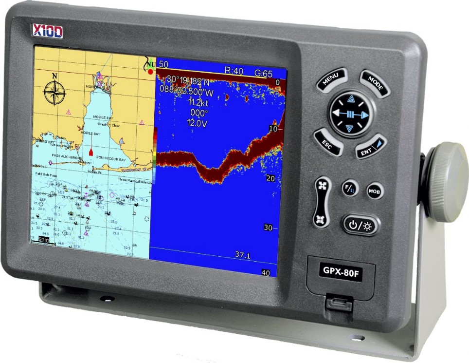
GPS Plotter With Fish Finder
8” Color LCD GPS Plotter with Fishfinder
Immediate availability
815.00 $
Add
Compatible with:


Want to know more ?
FEATURES | ||
8.0″ Color LCD GPS Cartographic Plotter/Fishfinder Combo
High Resolution: 8.0 inches Color TFT Display,640×480 pixels
8 Color or 8 Level Amber Presentation
50/200 kHz Transceivers,Output Power: 600 Watts
Blue, Light Blue, or Black Background Color
8 Range Scales, from 0-15 to 0-1000 Feet
Range Offset to 1000 Feet, Maximum Offset Range of 2000 Feet
Automatic Range and Gain Selection Mode
A-Scope Display for Rapid Fish ID and Detection
Multiple Display Modes:
- Single or Dual Frequency
- Bottom Zoom
- Bottom Lock Expansion
- Marker Zoom
- Navigation Data Screen
- A-Scope
Digital Displays of Speed, Depth, Water Temperature*, and Position
Adjustable Bottom or Fish Alarm
Calibration in Feet, Fathoms or Meters
Built-in Picture Simulator
Versatile display mode include
Adjustable Bottom or Fish Alarm
Calibration in Feet, Fathoms or Meters
Built-in Picture Simulator
SD-cards slot for Cartography or user data
Vector-Charts selectable tipes: our own (preloded, free of charge) - C-Map (at cost) - Navionics (at cost)
Tide tableVersatile display mode include
- Plotter Screen
- Plotter+Sounder
- Sounder
- Nav.Data
- Satellite Information
- AIS Display
- Compass Screen
GOTO track navigation
MAP orientation select
Proximity waypoints alarms
Perspective View
MAP Palette
MAP orientation select
Proximity waypoints alarms
Perspective View
MAP Palette
- Normal
- Daylight – exposed to sunlight
- Night – in dark environment
- NOAA – paper chart colors
SPECIFICATIONS | ||
PLOTTER CHARACTERISTICS | |||||||
Waypoints/icons | 15,000 waypoints with name, symbol, 10 proximity waypoint. | ||||||
Routes | waypoint up to 200 points each, plus MOB and Track Navigation or Goto Track modes. | ||||||
Tracks | 30,000 point automatic track log; 15 saved track (up to 2000 track points each) let you retrace your path in both directions. | ||||||
Alarms | XTE, Anchor drag, arrival, speed, voltage, proximity waypoint and time, AIS alarm. | ||||||
Pallete |
| ||||||
Tides | Tide data | ||||||
Projection | Mercator projection | ||||||
Position format | Lat/Lon | ||||||
Basemap | Vector-Charts | ||||||
External Map | SD Cards slot for C-Map Max and Navionics | ||||||
User data storage | Internal backup of user settings, or external SD-card | ||||||
Plot Interval | 1s to 99h or 0.01 nm to 9.99nm | ||||||
Plotting scales | 0.01nm to 1,000nm | ||||||
Nav Data | Inputs: $–DBT, $–DPT, $–GGA, $–GLL,$–GSA, $–GSV, $–HDG,$–HDM,$–HDT,$–MTW, $–RMB,$–RMC, $–VTG, $–ZDA, $–VWR,$–VWT,$–MWD, $–VPW Outputs: $–AAM, $–APB, $–BOD,$–BWC,$–GGA, $–GLL, $–RMB,$–RMC,$–VTG, $–XTE, $–ZDA Outputs for autopilot: $–AAM, $–APB, $–BOD,$–VTG | ||||||
Perspective View | On/off | ||||||
POWER SUPPLY | |||||||
10.5 to 35VDC, current drain 1.0A at 12V | |||||||
PHYSICAL | |||||||
Size | 290mm(H)X195.5mm(W)X99.5mm(D) | ||||||
Weight | 2.43kg | ||||||
Display | 8.0 inches ColorTFT Display, 800 X 600 pixels | ||||||
Waterproofing | Display unit: IPX5 Antenna unit: IPX6 | ||||||
Temperature range | Display unit: -15℃ to +55℃ Antenna unit: -25℃ to +70℃ | ||||||
GPS RECEIVER CHARACTERISTICS | |||||||
Receiver | 50 parallel channel GPS receiver continuously Tracks and uses up to 50 satellites to compute and update your position | ||||||
Acquisition times | Cold start: 27 seconds average Warm start: 27 seconds average Hot start: 1 seconds average | ||||||
Update rate | 1/second,continuous | ||||||
Accuracy | Position: 2.5 meters(95%) without S/A Velocity: 0.1 Meter/sec without S/A Time: ±100ns synchronized to GPS time | ||||||
Dynamics | Altitude: 50,000m Max Velocity: 500 m/s Acceleration: 4g Max | ||||||
Datum | WGS 84 & Others | ||||||
Interfaces | NMEA 0183 input and output,RS232 and RS422 output | ||||||
Antenna | GAX-07 | ||||||
AIS INTERFACE | |||||||
Data input | NMEA 0183 , R8232 | ||||||
Baud rate | 38,400 | ||||||
ECHO SOUNDER | |||||||
Echo Color | 8 colors (including background color) according to echo intensity. Monochrome display is also available. The background color is selectable from blue, light blue, white and black. | ||||||
Basic Range | Meters 5/10/20/40/80/150/200/300/600Feet 15/30/60/120/200/400/600/1000/1500 Fathoms 3/5/10/20/40/80/100/150/200 Passi/Braza 3/5/10/30/50/100/150/200/300 The basic ranges can be changed on the system menu. | ||||||
Range Shift | Up to 300 meters (1500 feet,200fathoms,300 passi/braza) | ||||||
Zoom Range | Times 2,3,4 and 5 ranges | ||||||
Bottom Lock Expansion Range | 5/10meters,10/20feet,2/5fathoms,2/5passi/braza | ||||||
Auto Mode | Automatic adjustment of range and gain | ||||||
Display Mode | High Frequency (200K),Low Frequency (50K), Dual (200K and 50K 1/2display on each), Zoom (200K and 50K zoom) and A-scope Display | ||||||
Zoom Display | Marker Zoom, Bottom Zoom and Bottom-lock Expansion | ||||||
Display Advance Speed | Lines/TX:Freeze,1/8,1/4,1/2,1/1,2/1 | ||||||
TX Frequency | 50 and 200kHz (alternately transmitted) | ||||||
Power Output | 600W | ||||||
Pulse-length/TX rate | |||||||
Display End Depth(m) | 5 | 10 | 20 | 40 | 80 | 150 | 300 |
Pulse-Length(ms) | 0.2 | 0.2 | 0.2 | 0.4 | 0.8 | 1.5 | 3.0 |
TX Rate(pulse/min) | 600 | 600 | 600 | 375 | 187 | 100 | 50 |
Interference Rejecter | Rejects unwanted signals by comparing last and present echoes in strength. | ||||||
Alarm | Fish and Bottom alarms, Temperature alarm (sensor required) | ||||||
EQUIPMENT LIST | |||||||
| |||||||
Screenshots | ||
